
Heat
MST. Chapter 30. Segment 7 (Part 2) & Segment 6

This is my serialized story of hiking the Mountains-to-Sea Trail (MST), a 1,175-mile route that crosses the state of North Carolina. I’m hiking west from Jockey’s Ridge near Nags Head on the Outer Banks of the Atlantic Ocean to Kuwohi (formerly Clingmans Dome) near the Tennessee border in the Great Smoky Mountains. If you’d like to start at the beginning of my story, click here.
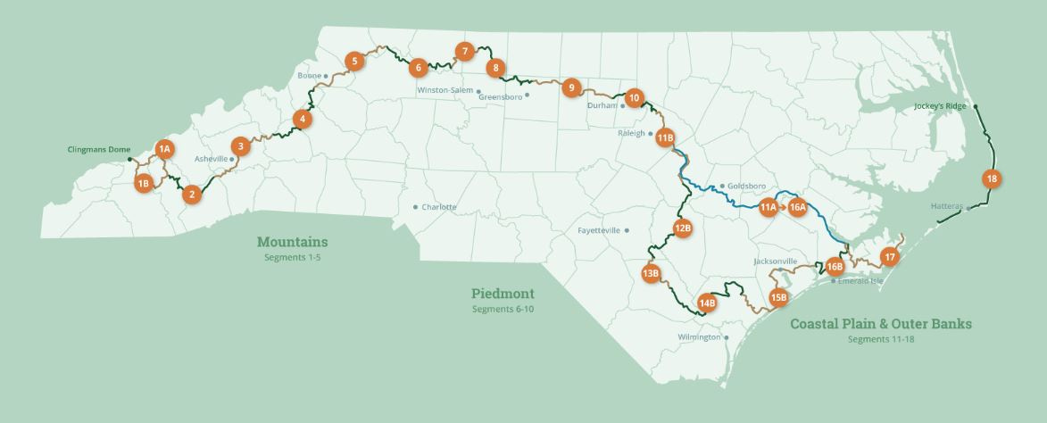
See the Mountains-to-Sea map at the bottom for reference.
“It’s too hot!” my wife, Karen, exclaims when I tell her I am planning to go ahead with my four-day hike starting tomorrow.
The East Coast is sweltering under a dome of high pressure, with average temperatures in North Carolina in the mid-nineties.
“This is crazy! AND for the last two days of your hike,” Karen points out, looking at the weather app on her cell phone, “the forecast calls for temperatures in the high nineties—maybe even reaching one hundred degrees.”
Clearly, she’s concerned, but, I know, too, she is trying to be supportive of my goal of completing the 1,175 mile Mountains-to-Sea Trail.
“Wasn’t this when you stopped last year and waited out the heat?”
“But I was in eastern North Carolina at the beach and all!” I respond. “Here, I’ve nearly reached the mountains. It’s got to be cooler in the mountains. Besides, I plan to stay covered, wear sunglasses, and I promise I will only hike in the early mornings and late afternoons. Remember, daylight saving time works in my favor.”
We are in our kitchen and I’m going over my proposed plan. Karen’s not buying it. “Early mornings and late afternoons,” she repeats, “not likely."
I reiterate, “I will avoid the worst of the temperatures and this time, you will be pleased to hear, I am carrying extra water.” On my last outing, I carried two one-liter bottles of water and couldn’t stay hydrated —several times, in fact, running out of water on my hike (but that’s an earlier chapter).
“This time I am carrying four one-liter bottles,” I assure her, and, perhaps, myself too —now hefting almost ten extra pounds of water on my pack. “I am more likely to die of a heart attack from the weight of the water than heat exhaustion from my thirst.”
“Hmmm,” she says, “but will the two extra bottles be enough?”
Over the next four days my goal is to complete Segment Seven of the Mountains-to-Sea Trail, which ends by winding eleven miles around Pilot Mountain. Then, I’ll continue on and tackle Segment Six by walking sixty miles across the Yadkin Valley in Northwestern North Carolina—Segment Six, most significantly, being the last road hike before I enter the third and final division of the MST: the Great Smoky Mountains or, more precisely, the Blue Ridge Mountains—within which the Great Smoky Mountains and Clingmans Dome, my final end-point, lie.
The directions for Segment Six have me passing through the city of Elkin, NC, the largest town on this section of the route. Elkin, from what I have heard, is the “unofficial” trail town of the Mountains-to-Sea Trail. It is the first town following the MST out of the Blue Ridge Mountains, or, in my case, the last town before I climb up into those misty blue heights.
“Given the fact I’m walking primarily on roads, I should pass plenty of convenience stores along the way,” I tell Karen. “And, if that isn’t enough, I can always call trail angels for help.”
Even though I was somewhat burned as a result of a trail angel who didn’t show up during a critical moment in my previous hike, I realize, in preparing for the walk ahead, I must still rely on angels (as instructed in the guidelines) to complete my saga.
Okay, okay, I am willing to admit that the angel no-show earlier at the Dan River was probably my fault. I should have stayed in touch with the volunteer who had, just a week earlier, agreed by phone and text to take me to a local campsite near the river. However, I didn’t contact her again, and it is likely she forgot. As a result of this surprising, late afternoon turn-of-events, that evening I ended up walking an additional seven miles to a campground in the town of Danbury (and that didn’t include the six miles of hiking up and down the wrong road).
I have to believe the Dan River situation was an outlier in my ongoing adventure hiking the Mountains-to-Sea Trail. Besides, I tell myself, this hike wouldn’t be much fun (?) if I didn’t experience a few hiccups along the way.
“I have been in constant contact with the trail angels in Elkin,” I tell Karen, “and two have agreed to help me.”
“This time,” she says, “I would appreciate having their names and cell phone numbers. If, for some reason, you don’t respond when I try to reach you, at least I can contact someone close-by who is aware of you.”
“You never know,” Karen continues, “you could fall and hit your head and how would I find you?…not to mention the possibility of dehydration and heat exhaustion.”
She points out again, “You, yourself, know you haven’t always shown the best of judgement when it comes to an adequate water supply.”
“But I’ve solved that issue,” I tell her. “and, as backup support, the trail angels will be there for me, I swear!”
One trail angel has agreed to pick me up in Elkin and drive me to Pilot Mountain. Starting at the Visitors Center, I’ll hike back to Elkin, before walking on to Stone Mountain, where another trail angel will drive me back to my car. He says he will let some friends know of my journey as I walk through.
The other trail angel, I might add, has sent me numerous texts about the high temperatures on the day he is to meet me, reminding me, too, to stay hydrated and giving me extra time to connect.
“I am sure I could contact either of them if I need help.”
My first angel will meet me tomorrow at seven A.M at the Heritage and Trail Center in Elkin where I will leave my car for the next four days. With his help, I’ll be at Pilot Mountain and on the trail by eight. Though this is a later start than I prefer, it does reduce the burden on Karen—this time, she won’t have to chauffeur me back and forth from Durham.
That night I pack my backpack and put it in the car. My alarm wakes me up at 3:00 AM and it’s time to get started. A shower, a bite of breakfast, a kiss, and reassurance I’ll come back alive, and soon I am behind the wheel for the two-hour drive to Elkin. I make it to the Heritage Center before the trail angel pulls into the lot at 7:00.
Bob Puckett introduces himself and tells me to load my backpack onto the back of his pickup. On our way to Pilot Mountain, he tells me how active he and his wife, Suzanne, are in assisting hikers. I’m impressed. Though they work full-time, they have committed their lives to helping hikers coming through the area. Before I leave him, he repeats over and over that if I need either he or his wife during my hike, I should call regardless of the time of day.
At the Pilot Mountain Visitors Center, before I begin my hike, I take time to go to the bathroom and, in looking in the mirror, I can see in my eyes how tired I am. I could use a nap or a cup of coffee, but neither will happen anytime soon.
Once again, with my FarOut app highlighting the MST trail, I find I start off in the wrong direction and must use the GPS tool in the app to locate where I am and how to get on track for the next four days.


Hiking around the summit of Pilot Mountain takes time and energy and I stop more than once to rest in the rising heat. Eleven miles on any given day is not a “walk in the park” and, here on this mountain, it requires treading lightly over roots and quartzite rocks. The trail is uneven and, at various spots along the way, I am directed over large boulders; it becomes clear to me, one misstep could be disastrous.
I am wearing new hiking shoes and I find that they are pinching my toes. These shoes are my third pair on this journey from the coast and, given I am using the same shoe from the same company, I should not be having problems.
Note to self (as if I didn’t already know this): never start a thru hike with new shoes.
As I rest and eat a protein bar, I assess my situation: up too early, hiking in hot, suffocating heat, bathing in high humidity, climbing over sharp, uneven rocks with four heavy bottles of water weighing a ton in my pack, and, now, suffering in these damn-too-tight shoes. What next?! Unfortunately, this is soon answered.
A mile or so later my right knee begins to throb, which only adds to my misery. With five miles completed and a full afternoon still ahead of me, along with three days of hiking to go, this source of pain is disconcerting. Could this be a result of the heat?
By the time I am on the next trailhead leading away from Pilot Mountain, I am positively limping. My hiking sticks, though, provide a strong source of support from putting too much pressure on my right leg.
At one point I hear, or rather, feel a snap in my knee and I immediately stop and grab my leg. Ouch! I slowly feel my knee cap looking for the source of pain and discover a lateral point on the inner side of my right knee which appears to be not too happy. My first instinct is to stand for a few minutes, drink several large gulps of water, and vigorously rub it away—hoping this will work.
I take a few tentative steps going forward, again relying heavily on my hiking poles, and discover my knee does, indeed, feel better—much better than stepping to the right or left. A second later I hear, or feel, another snap and whatever had happened previously now feels like — whatever that was — has snapped back into place.
I am so relieved, but, as I continue, I realize I may be hiking in pain for awhile.
From here on in, I resolve to only walk forward, never side-to-side, and only up and never down—even though I am following a long descent off of Pilot Mountain with more than five miles to go.
I stop and take two ibuprofen tablets and that helps. So too, my toes feel better, my shoulder, aching from my backpack, feels less painful, and all’s right with the world.
It’s slow-going, but, I realize, I can do this. At least, I won’t need to call Bob or my wife Karen to come get me—not until, at least, I get down to the trailhead where Segment Seven ends and Segment Six begins.
Two hour later, I reach the trailhead and look for shade to get off of my feet, but I don’t see obvious shade anywhere. I am simply at an open parking area. Finally, I sit near a hitching post for horses where I have found the tiniest sliver of shade on the entire lot.
I give my knee a rest and eat a lunch consisting of another protein bar and the last of the energy balls Karen made for me for the hike. I spot a porta-john nearby. I limp over to relieve myself, happily reducing my stress. Amazing how going to the bathroom can change the circumstances in which one finds oneself.
Though I finished off two bottles of water on the trail getting here, I still have two bottles remaining and that feels good. For once, I am not in a dire dehydration situation. Thank god!
A truck with a horse trailer pulls into the dry and dusty lot. Soon a middle-aged man wearing an old tee-shirt and shorts, gets out of the truck. What’s most remarkable is his worn cowboy boots. He waves to me then turns to the back of his truck. He opens the trailer door and backs out his horse, which is already saddled and ready to ride. I pack up and proceed past him out of the lot.
“Isn’t it too hot to be riding in this heat,” I ask him.
He says, “Naw, I ride three or four times a week year-round.”
I shake my head at that. “It’s definitely hot today,” I say.
He asks me if I still saw water on the trail, which I did—spotting several active streams. He says he’ll ride up the trail a ways as long as he can give his horse water.”
I wave adios and wish he and his horse good luck as I proceed to limp up the road away from the trailhead and the end of Segment Seven of the MST.
Thinking about it, it turns out, Segment Seven was almost all trail from Hanging Rock to the backside of Pilot Mountain — something like a total of thirty-five miles. This was a spectacular hike through the Sauratown Mountains, but, clearly, it did not come without its bumps and bruises—and a tweaked knee too.
I walk for nearly three miles along remote farm land with beautiful vistas of the mountains to reach my night’s destination: the Ararat Campground. There, they are surprised to see me given the heat, and I am surprised to be told that MST hikers can camp for free. Great news, though I am the only camper in a long line of RVs. Nevertheless, I set up my tent and get off my feet. It’s time to do whatever I can to rest, elevate, and exercise the ligaments around my right knee.
I have borrowed my daughter Helen’s air mattress for this four-day hike, after mine wouldn’t stay inflated (even with a patch). Maybe the camping stuff I’ve been carrying with me since the start of the MST at Jockey’s Ridge on the Outer Banks, along with my aging body, is simply wearing out.


The tent is hot and, as the afternoon sun drops to the horizon, the shade where I set up my camp wanes, and soon my tent is cooking like an oven in the heat. I get out after a sweaty nap and sit at a picnic table in the shade away from my tent. It’s a tough couple of hours waiting for the cool of the evening while trying to keep from using my knee. Later, back in the tent, when I am not dozing, I exercise my leg and the ligaments around my knee, and feel by that night that, maybe, I’ll be okay.
The next day I am definitely limping when I get up and go to the bathhouse. I am hoping that walking on roads will be much easier than hiking on a rough trail, and am actually glad, for once, to spend the day on hardtop—if only as a healing exercise for my knee. I can’t help but wonder, though, if this is any indication of what hiking three hundred and fifty miles of mountain trails to Clingmans Dome will be like for me physically. I may not survive this crazy dream!
I fill up my four water bottles at the bathhouse and am back to full strength when I leave the campground. At six-thirty in the morning, a man steps out of his RV and tells me to stay safe in this heat. I give him a thumbs up and start my journey once again. I can’t help but think this campground was a godsend. After fourteen miles yesterday, eleven on trails, I really needed a spot to rest, regroup, and sit out the heat.
Four miles into my twenty-nine mile hike to Elkin, I spot a pizza restaurant in the tiny town of Siloam near the Ararat River and realize it is open even at this early hour. I stop in, looking for coffee and whatever they might serve other than pizza. Half of the layout, I discover, has been setup as a convenience store with all sorts of staples on its shelves, and the other half is a tiny restaurant with a select number of tables. I take off my pack, then go to the counter and buy a large cup of coffee.
Back at my table, I notice the chalk menu above the register offers biscuits and other breakfast items. I limp back to the register, once more, and order a cheese omelet. That’s exactly what I get — no toast or home fries —just the orange-looking pancake- of-an-omelet that, I must say, even though the cheese is not vegan, tastes great. I still have three-and-a-half liters of water at this point, with only ten miles to go to reach my next stop—the general store in the historic town of Rockford where I plan to eat lunch and replenish my supplies for the afternoon. Given the short distance, coffee, a large styrofoam cup of water, and a down-home omelet and I am good to go.
An older man, who, at first, is the only other customer in the store, decides to come over and introduce himself. He says his name is Jerry and he is from this area. He tells me the town was once a cross-roads with a wooden bridge over the Ararat River nearby. He points to a poster his wife set up on the wall near the bathrooms. It turns out, part of the old bridge collapsed in a storm back in the 1970s. His wife’s parents were in one of six cars that drove off the bridge in a thick fog.
“That’s horrible,” I tell him. I am so sorry for their loss.” He says he and his wife were living in Raleigh at the time and came home to work the farm after that. They’ve been here ever since. I see from the poster that the story made the headlines in Winston-Salem. Jerry says Siloam was famous for awhile.
I think of my mother who died in an airplane crash forty years ago and how such an event can change the lives in a family so suddenly. “I am sure it must have been devastating for your wife and her family,” I say. “Though it was a long time ago, I bet every thing changed after that.” Jerry smiles and nods his head.


By the time I am ready to leave, the store has slowly filled with locals: rickety couples in their eighties and a half-dozen older women who arrive in their off-year cars and pickup trucks. They move tables and chairs to sit together and it seems to me this might be how each morning begins. I am the stranger interrupting their routine. I give up the chairs at my table, then stand to go, drinking the last of my coffee.
They are curious about me, without imposing, aware of me, but not asking. When I lift my backpack onto my shoulders, Jerry tells everyone I am hiking to the Great Smoky Mountains. A number of the women speak up and tell me to be mindful of the heat, to drink plenty of water, and to stay safe.
I tell them, “Thanks! I only need to get to the Rockford General Store ten miles ahead.”
They seem relieved. But, for the life of me, I don’t know why I said this. In truth, I have twenty-five miles still to go on a sore knee. This with the heat rising into the mid-nineties before I can sleep tonight.
Click here to read the next chapter.
Click here to read the previous chapter.
Map of the Mountains to Sea Trail. This post focuses on Segments 7 and 6.
Reassuring folks (including yourself) as you go.
Aaaccchhhhhh! Hiking in the heat is terrible! Get some salt/electrolytes to go along with the water!