


Hiking Memories
MST. Chapter 25. Segment 10

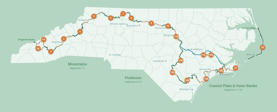
This is my serialized story of hiking the Mountains-to-Sea Trail (MST), a 1,175-mile route that crosses the state of North Carolina. I’m hiking west from Jockey’s Ridge near Nags Head on the Outer Banks of the Atlantic Ocean to Kuwohi (formerly Clingmans Dome) near the Tennessee border in the Great Smoky Mountains. If you’d like to start at the beginning of my story, click here.
See the Mountains-to-Sea map at the bottom for reference.
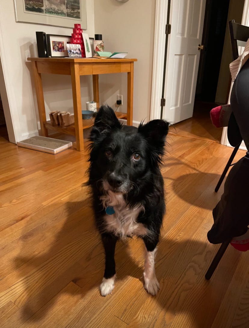
Without realizing it, the four days of hiking Segment 10 of the Mountains-to-Sea Trail brings back many memories of walking this segment five years earlier with my border collie, Rosie.
Back in the fall of 2019, I hiked Segment 10 both east and west with our recently adopted seven-year-old dog, who, we discovered, loved to go on hikes. This segment of the MST, seventy-eight miles long (156 miles total in both directions), consists of a forested trail through public game lands along the western side of Falls Lake northeast of Raleigh. At the Eno River, the trail turns westward north of the city of Durham, following the winding river towards the Great Smoky Mountains. Rosie and I loved this trail and bonded together as we hiked its entirety over a four-month period.
In truth, it’s never as simple as that, or perhaps, it is.
I retired from my desk job at the end of June, 2018, and found myself at a loss as to what I wanted to do. I sat at my desk at home and began to write a memoir of growing up in rural Pennsylvania, but I hated being at a computer all day/every day just like when I was working. I longed for a new direction.
In May, part of my answer came in a form of a seven-year-old, forty-pound border collie who we watched over for two weeks while her owner, a young man in the Coast Guard, visited his father in California. Later, when he returned, we learned he had received orders to be deployed on a Coast Guard cutter. We couldn’t imagine what he would do with the dog and ask if we could keep her permanently.
Long story short, given his situation, he agreed it would be best.
It turns out Rosie was the perfect thing for me too!
Border collies, I learned, like to exercise. Soon our twice- to three-times-a-0day walks morphed into longer hikes, and within several months we had completed all the local trails in the area—some several times. I was free of my desk and she was free from sitting alone in an apartment for seven to nine hours a day while her owner worked at the Norfolk naval base. Segment 10 proved to be the perfect challenge for the two of us. From trailhead to trailhead we would hike out from/and return to my car, and, as a result, we competed the trail in both directions by December.


I had been a long distance runner and, after a number of marathons, including Boston, New York and Chicago, I succumbed to a series of injuries. In particular, two bouts of plantar fasciitis ended my running career. Inevitably, I gained weight and stopped exercising. Adopting Rosie and hiking almost on a daily basis, I discovered a new exercise routine that got me active again and suggested a lifestyle that could invigorate my retirement years. She was the spark.
Five years later, after COVID, after my weight issues, after recovering from prolonged bouts of plantar fasciitis, after walking five hundred miles across Spain on the Camino de Santiago with my sister-in-law, and after a daily commitment to a local workout gym, I stood ready for the 1,175-mile Mountains-to-Sea Trail across North Carolina.
Now, after hiking eight segments heading west from Jockey’s Ridge to the Great Smokies, here I am staring, once again, at a map of Segment 10 of the MST. Only, this time I will hike it without Rosie. Given her age and the average number of miles I walk each day, my family and I felt it would be cruel to take her on this adventure.
When I leave the house to tackle this next segment, she looks at me like she knows what segment it is I’m about to do, like I am a traitor and I am—I am.
My wife Karen and daughter Helen drop me off on a cold morning in late March at Falls Lake Dam where I ended my previous hike. This go-round I am not planning to take four months as I did the first time with Rosie, but expect to hike Segment 10 heading west in a total of four days. This is section-hiking at it’s finest with camping at two of the state’s recreational campgrounds along the lake and one night spent at a “primitive” site near the confluence of the lake and the Eno River.


For this segment I bring my hiking poles. I used them extensively on the Camino in Spain and for day-hikes on the Appalachian Trail over various holidays, and now I feel good having them back in my hands again as I hike the forested hills around the inlets of Falls Lake. This walk, the first day, is fun and fast, though I am surprised how frequently I am reminded of being with Rosie at different points along the way.
I stop consulting the printed directions I carry as the white MST blazes on the trees are super frequent on this section of the trail. In fact, it is only at bridge crossings that I run into trouble. The first bridge I encounter I confusingly think the trail picks up on the other side of the road, but it doesn’t. A white blaze that I didn’t see at first but has been painted on the bridge guard rail is an indication I should cross the bridge and resume my hike in the woods on the other side. To be certain, on my cell phone I turn on the GPS tracker on my FarOut app showcasing the MST trail and quickly correct my mistake.
At the third bridge, I am now used to this routine and cross over the inlet. Unfortunately, I walk a quarter-of-a-mile beyond the bridge before realizing I don’t see any blazes and don’t know where I am going. I turn on the GPS tracker, once again, and discover that I have walked way off course. I am officially in the middle of nowhere. It turns out, this time, I should have entered the woods on the other side of the road—and not cross the bridge at all! Wouldn’t you know it. You can’t take anything for granted coming out of a forest.
Losing this time, though, and adding another mile or so to my twenty-two-mile goal on this first day of my hike is a royal bummer. Not only does it extend the length of how far I need to walk, but, given I started late in the morning after being dropped off by Karen and Helen, I estimate I will arrive at the state-operated Shinleaf Recreational Campground not in the late afternoon, as I had hoped, but now, just before sunset.
When I finally get to Shinleaf, I am tired and ready to put up my tent and get off my feet. The reservation I made on line says I am to go to campsite #16, but the campground map displayed in the kiosk at the front entrance indicates that #16 is located miles from the bathroom and bathhouse. As I see the campground is deserted, I contemplate sneaking over to Campsite #1 near the bathrooms.
Just then, a park ranger drives up through the empty parking lot and slowly stops at the kiosk. He gets out of his car and smooths his dark green jacket and pants and puts on his hat. He looks like the kind of ranger you’d see on tv telling kids not to start forest fires. He walks over to me and asks, “Do you have reservations?”
“Yes,” I respond, “but please tell me I don’t have to stay at site 16,” My eyes are pleading. “I’ve walked too long today to be so far from the bathrooms.” I am all but saying: can we make a deal? I don’t have cash, but I could pay you in trail mix and jelly beans. After all, does it really matter where I sleep in this desolated campground?
He pulls a paper from his pocket and says, “You’re confused. You’re at site "#2.”
“Oh, thank god! Thank god!”
He smiles at that, looking at my twenty-five pound backpack. “Site 2 is much closer, don’t worry.” He pauses, then tells me the outside water spigots are turned off due to the freezing temperatures. “But,” he says, “the bathroom sinks still operate.”
“Great.” I say, as I put my backpack down on a recycle bin and pull both of my nearly empty water bottles out of my pack’s side pockets. “I definitely counted on getting water here.” It goes unsaid that if he had told me the sinks were shut down along with the spigots, I would have had to kill him.
Campsite #2 is just down the way from the bathrooms, and I am able to refill both of my water bottles and set up my tent before night fall. After a twenty-three-mile-day, I rehydrate and heat up my dehydrated meal of “Kale and White Beans” and am soon asleep in my clothes with my winter cap and gloves on and my puffy quilt pulled tight.
Unfortunately, I have given up on a Zoom call with a group of high school friends. I suspect I am the only one in my class at this stage thru-hiking, let alone attempting it at this time of the year, but I’ll have to join them on Zoom the next time—that is, if I don’t get eaten by a bear—being the only camper in a campground with 50+ camping sites, the odds are pretty good that if the bear walks in hungry, I’m dinner.
I survive the night (no bears!) and, with a short day of hiking fifteen miles to the next recreational campground, I decide to visit friends who own and operate MoonDance Soaps, a small enterprise about a mile-and-a-half off of the MST trail. After a four-mile hike to get to the highway, I walk the extra thirty minutes to their door.
Though Jessica, with whom my daughter Helen and I often interact at our local Farmers Market, is not there, I meet up with Christy and Suzanne, two of her staff members, and her husband Tucker. It is fun taking time off from the trail to interact with them and tour their operation. Truly, what a cool business and what a wonderful selection of soaps! If you have not heard of them or are not using their soaps, I highly recommend taking a second to compare your soap with theirs. Check out MoonDance Soap here if you’re curious.


Tucker asks me if I want a complimentary bar of soap for the road, and I say, no, I already carry a bar of their soap in my backpack. What more can anyone ask for in a soap—it lathers and comes in many unique, yet subtle, fragrances, and at the same time, it can handle the needs of a backpacker!
A short-time later Tucker drives me back to where I left the trail and I continue my trek along Falls Lake. Hiking past the lake is not the same, of course, without my dog. The lake is always in the distance and beautiful, but, with Rosie, we would go down to the water to check things out. Rosie aways took a swim. Sometimes she would fetch sticks I would toss. In truth, there’s something about a lake and a dog that can’t be duplicated without that one key ingredient—the dog.
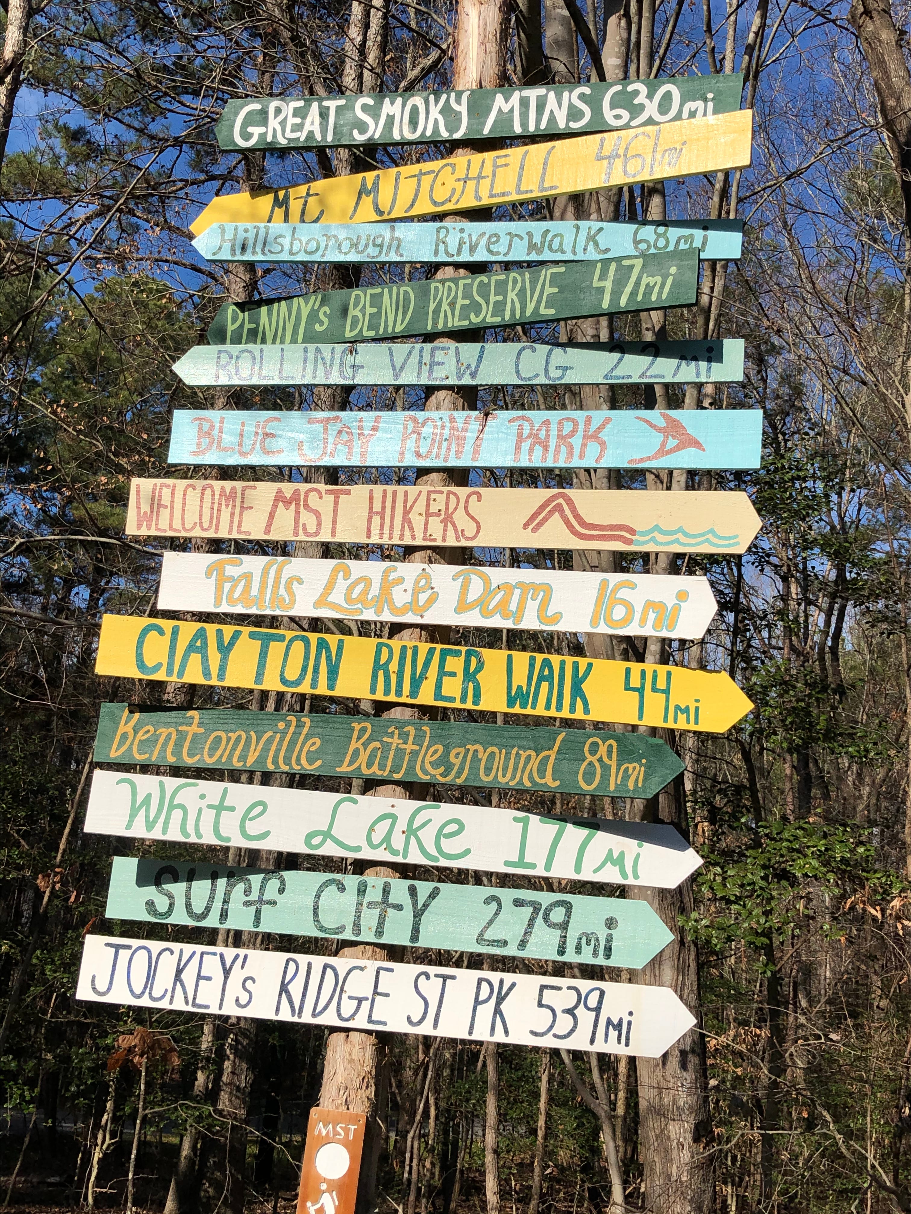
Mid-afternoon I pass a bench with locations spelled out for hikers on the Mountains-to-Sea Trail—both for those hikers heading east as well as west. I am thrilled to think that according to whoever did this bench, I will reach my halfway point on the MST sometime tomorrow when I attempt another twenty miles or so.
At around five o’clock the trail leads me out of the woods to the entrance to the Rollingview Recreational Area where at this time in the year, just like at Shinleaf, plenty of tent locations and RV sites are available. The campground designated for tents, though, is another half-mile from the main gate and well beyond two campgrounds for RVs, but, I’m here, who’s complaining! My campsite, #16 I discover, is in a beautiful location and the bathhouse close by offers hot, ferocious showers.


The next morning I am up early and on my way. I plan to hike twenty-three miles today to reach a primitive campsite, called the Ward Campground, that I had toured previously with Rosie. In fact, all three of these campgrounds I visited with Rosie and felt like one day we would camp at each of them. Now here it is happening, only I am without my dog. She, though, is a presence I recall vividly at these sites and wish she was here barking at squirrels and running ahead of me.


Knowing I would be hiking to a primitive campsite, I prepared ahead of time by purchasing a two-liter plastic water sack, called a platypus, that I keep rolled up in my backpack. Now, before leaving Rollingview, I fill up the plastic bladder, along with my two bottles, and pack the platypus into the top of my backpack. Two liters of water weighs an additional four-and-a-half pounds, but I have no choice—I will need the extra water for tonight and tomorrow. This is my experiment for this trip as well as for future hikes where water will be an issue. I have had so many water problems on the MST—after five hundred miles, I hope my new platypus may finally solve this issue.
Walking on forest trails takes longer than walking on roads and instead of maintaining a pace of just under four miles an hour, I am now averaging a little over three miles an hour. A twenty-three mile day means I’ll walk for approximately eight hours. My pack, lighter with less food, given my consumption from the previous two days, is now noticeably heavier with the extra water. I am probably carrying thirty pounds or more.
Before leaving Rollingview, I cinch up my pack, but I know I’ll feel it by mid-morning.
Falls Lake is a 12,410-acre reservoir that looks like a flat hand with fingers pointing outward in all directions. Created by the Army Corps of Engineers in 1981, it extends twenty-eight nautical miles up what used to be the Neuse River to the confluence of the Eno, Little and Flat Rivers and is intended to control flooding and provide a water supply for Raleigh and surrounding areas. Another benefit has been its recreational uses for locals in the area—from boating, to fishing, to hiking along its shoreline.
A hike along Falls Lake, working around all of its inlets, is much further than twenty-eight nautical miles—more like double that distance. The water I carry, with an additional twenty miles following the Eno River to complete Segment 10 of the MST, will have to last until tomorrow when I reach a water source in Durham.
The twenty-three-mile hike I am on today feels every inch of the distance and when I leave the swampy head waters of the lake to follow the “flow” of the Eno River, I am glad for the change. I don’t see the Eno River at all in that final ten miles to the primitive campground, but I am glad to be hiking west, north of the city of Durham. I follow a tunnel under I-85 and pause to reflect. Reaching I-85 is another milestone, but it is also a spot where Rosie and I were lost five years ago before the FarOut app, and, after thirty minutes, we finally figured out where to turn to stay on the trail.
Around four o’clock in the afternoon I arrive at the Ward Campground and am relieved. The miles came off easily at first but started to slow me down by the end. The campsite is nicely outfitted with a pavilion and benches around an open pit fireplace. This must be the “Cadillac” of primitive campgrounds. In the large pavilion the owner has stashed a large green tub of bottled water and snacks for thru-hikers. I immediately drink one of the stored bottles and eat a small bag of potato chips. The water and salty chips are wonderful!
My own bottles are empty from today’s hike, though I am still carrying water in the platypus in my pack. My plan is to use the platypus for tonight and tomorrow’s hike. However, with the extra water from the campsite that I wasn’t counting on, I am in heaven. I make myself a hot cup of instant coffee and take a second to just sit at the picnic table and regroup. Rosie would have loved camping with me at this location.
That night four hikers who look to be in their twenties pull into the campsite. They lower their voices when they see my tent, but, nonetheless, are happy to be here. They go ahead and set up their tents while enjoying the last of the daylight, but then, sit and talk at the long table in the pavilion before going to bed. I think about getting up, putting on my trail shoes and visiting with them, but decide I would rather sleep. Tomorrow will be a long day and forecasters are calling for bad weather.
At four a.m., I wake to the sound of rain on the tarp covering my tent. Luckily, hearing a short letup at around five a.m., I sit up and am on the move inside my tent packing my backpack. I carry everything to the long table in the pavilion, then make another hot cup of coffee while I finish packing—including rolling up my tent into the wet tarp and attaching it to the bottom of my pack. When I am done, I sit listening to the rain picking up while everyone else in the campground continues to sleep.
I don’t know when the other hikers will wake or in which direction they are heading, but at five forty-five a.m., I am back on the trail hiking west. I have a rain cover for my backpack, and my head lamp turned on under my raincoat’s hoodie. Though I don’t like hiking at night due to exposed roots, rocks and pockets of standing water, I have eighteen miles to go before reaching the trailhead where Karen will pick me up, and, in the driving rain, this sounds like a daunting proposition.


Finding the white blazes on the trees at night isn’t difficult with my head lamp and, most significantly, the light from the lamp doesn’t appear to be affected by the rain. I make good time and am out of the woods in two hours. Crossing a scary bridge with on-coming, rush-hour traffic in the rain is a mind-trip, but I quickly turn into Penny’s Bend Nature Reserve and start to walk along the swollen Eno River.
When I get to the “West Point on the Eno,” an old mill operation turned into an active city park with a working grist mill, a wonderful photography museum, historical buildings and environmental education pavilion, I am water-logged. It’s about nine-thirty in the morning and from here I’ll hike the well-worn trails to the Eno River State Park. But before I do, this is where I plan to take a break and get more water—my platypus now nearly empty.
Rather than go to the picnic area with bathrooms and a water fountain, I spot a restaurant on Roxboro Road heading north out of Durham, and decide, in spite of a let up in the weather, to go inside to dry off and eat breakfast. I order a vegetarian burrito, home fries and toast along with a pot of black coffee. It’s wonderful—so much better than a cup of oatmeal cooked on my little camp stove.
My backpack and hiking sticks sit out in the aisle next to my booth, but no one complains. The waitress, in fact, brings me an additional pitcher of water, which I use to fill up my water bottles. After breakfast, she asks me at the register if I want an umbrella, which I graciously decline. I can’t imagine, I tell her, how I would handle an umbrella along with the two hiking sticks. She says that’s too bad, as it’s supposed to get rough outside. “Are you sure you don’t want an umbrella?”
Less than a mile into my hike along the Eno River, I find myself in an intense deluge of rain. It’s like, as they say, the heavens have opened up. I quickly move my cell phone into a plastic bag, but it is already too wet from taking pictures. I have to stop using it. Of course, this is when—out-of-the-blue—my wife Karen texts me to ask if I want her to pick me up. The rain makes it difficult to read the text, let alone respond. Still, given where I am, I am not sure how she could pick me up unless she brings one of those hard-as-nails boats that navigate class-four rapids through the Grand Canyon. I’m good, I tell her and keep walking.
I recall an article I read in Backpacker Magazine where the author said, “A journey is of no merit unless it tests you.” Clearly, this is a test worthy of my four-day hike.
By the time I reach the trailhead nearest to my house it’s early afternoon. I have had to work my way across gushing streams/waterfalls and along significant stretches of swamped trail. I am totally soaked, including my shoes, which, alone, will need at least a couple of days to dry out. I couldn’t imagine putting up a tent in these conditions. In fact, there are no campgrounds nearby. In the guidelines, thru-hikers at the end of Segment 10 are directed to a motel a mile off the trail. At this point, a motel sounds great, but not as great as getting picked up by my wife and driven home.
I truly believe, Rosie,my eleven-year-old dog—going on twelve in a month—could not have handled this four-day hike up Falls Lake and along the Eno River. The rain, itself, on this final day would have been a disaster for her—for both of us. I am so glad Rosie stayed at home and is dry and healthy and happy to see me when she greets me at the door. In spite of the many good memories of us walking together through this segment of the MST, I am relieved I didn’t add my four long hikes and such tough, difficult conditions today to the story of our time together.
Maybe I’ll bring her when I get to the mountains—now just 230 miles away. Rosie, hiking with me in the Smokies, would make for one heck of a great memory!
Click here to read the next chapter.
Click here to read the previous chapter.
Map of the Mountains-to-Sea Trail. This post focuses on Segment 10.
I know you really missed Rosie on this section on the MST. But your trail memories of her sustained you through this segment. Congratulations! ❤️ M
Looking forward to hearing how the hiking changes with the temperature differences and learning where you are now in this process. Love the adorable family photos!