


Hallowed Heartland
MST. Chapter 24. Segment 12 (Part 2) and Segment 11

This is my serialized story of hiking the Mountains-to-Sea Trail (MST), a 1,175-mile route that crosses the state of North Carolina. I’m hiking west from Jockey’s Ridge near Nags Head on the Outer Banks of the Atlantic Ocean to Kuwohi (formerly Clingmans Dome) near the Tennessee border in the Great Smoky Mountains. If you’d like to start at the beginning of my story, click here.
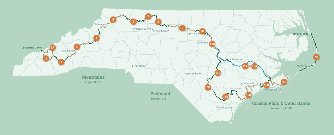
See the Mountains-to-Sea map at the bottom for reference.
I gotta get to the mountains! My plan is to hike one hundred miles across North Carolina’s agricultural heartland in the Eastern half of the state and reach Falls Lake Dam in northeast Wake County by the end of a five-day push. I won’t arrive at the mountains—not yet, anyway—but I’ll get the reward of seventy-eight miles of actual “real” trail. “Falls Lake or Bust” is my slogan. I would run to the dam if I could, but still, if I put in the road work here in finishing Segment 12 and tackling 11 of the Mountains-to-Sea Trail, my next thru-hike will be nothing but forest trails in Segment 10.
For now, the state parks and forests appear to be either behind me or one hundred miles in front and what lies immediately ahead are endless roads and acres and acres of agricultural land. This all before I complete my hike on greenways that edge around the cities of Smithfield, Clayton, and Raleigh. As I will be passing convenience stores along the way, I leave at home my three-liter Camelbak water system that fits inside my back pack and take two twenty-four ounce Contigo water bottles that can easily fit into my pack’s outer pockets. In addition, since my last hike I’ve purchased a puffy quilt, instead of a sleeping bag, that stuffs down into my pack and weighs only 19 ounces. After my experience with using a lighter puffy blanket back in January, I am looking forward to testing my new down-filled quilt.
On Saturday morning my daughter Helen drives me an hour-and-a-half to Salemburg in Sampson County down I-40 and I-95 in the lower mid-western part of the state. This is where I left off the trail my last outing, and where, after a quick departing hug from Helen and a pee behind the bushes, I start my journey.


My goal today is to reach the Vann Crossroad Fire Station twenty-three miles away. Once there, Fire Chief Williams has given me permission to camp for the night. Twenty-three miles, though, hiking on paved roads over undulating farmland proves to be tough, and seven hours later when I reach the fire station late in the afternoon, my feet are both tender and sore.


The station, I discover, is smaller than the fire station at Beaver Dam, near Roseboro, North Carolina, where I had such an enjoyable reprieve from the trail with fire chief, Gary Brock, and his wife, Eva. In fact, with Eva and Gary’s help I made it all the way to Salemburg on that trek. That last afternoon Eva picked me up in little Salemburg’s one-stoplight downtown and brought me back to Beaver Dam to join in their family’s festivities celebrating her birthday. What wonderful family and what a great capstone event after five tumultuous days of hiking!
On this occasion, due to the smaller size of the Vann Crossroad fire station, I put up my tent in the grassy side yard. Chief Williams gives me access to the facilities, though, and I am thrilled to have a bathroom at my disposal and a kitchen to wash my utensils and replenish my water. That night as I listen to evening chimes from a local church, my sense of contentment is intoxicating.


On Sunday I expect to walk ten miles to the Bentonville Battlefield, eat lunch, and then, hike ten miles further to the Howell Woods Environmental Learning Center in southern Johnston County. The hike to Bentonville takes longer than I estimate, but it comes with one big surprise: I cross back over I-40 after first reaching it heading west right before the town of Burgaw. Now I am back on the highway’s eastern side, a positive sign I am making progress.
The Bentonville Battlefield Visitors Center, I discover when I finally get there in the early afternoon, is closed on Sundays, and, with it, the bathrooms and water fountain I counted on being available to me. Not knowing this ahead of time is a major mistake on my part and reminds me, once again, of how difficult Sundays can be for thru-hikers and how important it is to get more into the details in planning my trip. The visitors center being closed changes my plans immediately: now I need to conserve what water I have left after the first ten miles—especially as I’m not sure the general store three miles away, also mentioned in the guidelines, will be open.
Rather than walk the trails around the Bentonville Battlefield, as described in the Mountains-to-Sea guidelines, I decide to stay on the road and get to that general store. Fortunately for me, two weeks earlier I hiked in the Bentonville Battlefield with Brent Laurenz and Betsy Brown from the Mountains-to-Sea Trail.
Brent is the Executive Director of the MST and Betsy, the Associate Director, and both led a small group of interested MST friends on a walk to highlight a new mile-long trail that MST volunteers carved out within the battlefield’s forest. Small MST gatherings, like this one, showcase the continued effort the staff and volunteers go through to slowly transform the MST into a true “trail” from the mountains to the sea.
Bentonville, itself, is interesting and a clear reason why the MST goes through this area. The battle here between Union and Confederate troops is the last major battle of the Civil War. Approximately two weeks later Robert E. Lee surrenders to Ulysses S. Grant in Appomattox, Virginia, and a week after that General Joseph Johnston surrenders his Confederate Army to William Sherman at Bennett Place in Durham.
The battle at Bentonville proved to be a vicious encounter between two tired armies over a wide swath of farmland and swamp forest with more than 4,000 casualties. Combined, four hundred and thirty-three men were killed during the three-day incursion, with the two sides often fighting in hand-to-hand combat. Less than a month later the war was over and everyone went home.
Sitting at a picnic table eating a power bar for lunch, I calculate it’s now about one hundred and sixty years later, and given the current casualness of the whole thing, what with the visitors center closed on a Sunday, this battlefield feels more like a testament to the waste of life. The outcome of the War had already been decided and now, so many years later, I am the only one here, sore feet and all.
If the Moore’s Creek Battlefield, just outside of Burgaw, is inspiring due to farmers and other volunteers stopping the British Army from advancing to Wilmington in one of the first battle of the Revolutionary War, Bentonville with its bedraggled, thread-worn troops on both sides of the conflict, is only sad and depressing—there is nothing heroic here. I can’t get over the fact that the war had been essentially over when both sides fought each other tooth and nail. Funny (and eye-opening) how the Mountains-to-Sea Trail passes through both battlefields in showcasing North Carolina’s history.


The ten-mile hike to the Howell Woods Environmental Learning Center, too, takes longer than I expect. I decide that Day Two on a five-day hike is always tough. I am already tired from walking with my twenty-five pound pack the twenty-three miles on Saturday and, of course, sleeping outside the fire station, and now my feet have definitely developed blisters from more than thirty miles this morning of hard road surfaces. In truth, I really need a long drink of water. Three miles on my way, the general store mentioned in the guidelines, I discover, is also closed on Sundays. I continue to ration my water as I walk the next seven miles to Howell Woods, where I have also been given permission to camp for the night.
As I walk the back county roads, and, for that matter, as I’ve hiked over the past day-and-a-half, the number of family cemeteries I encounter along the way is surprising. This beautiful farmland, I surmise, appears to be handed down from generation to generation. I am walking past land that families long ago cultivated and made their own. What is it that Abraham Lincoln said? “Hallowed ground.” Fought for and held closely into perpetuity family member by family member.
By mid-afternoon I arrive at Howell Woods and have completed Segment 12 of the Mountains-to-Sea Trail. I can’t celebrate this, unfortunately, as I discover, once again, that the visitors center is closed on Sundays. So, too, the bathrooms are locked and the water fountain shut off. I need fluids, that’s critical. Luckily the vending machines outside the amphibian classroom work just fine and with my credit card I purchase two bottles of lemon-lime Gatorade: the first I drink down in minutes and the second I treat like a fine wine. I spot, then, while sitting on an Adirondack chair on the large veranda, that the spigot with the garden hose might still work, so I get up and turn the valve and clear water pours out of the hose into the yard. I replenish both of my water bottles, thoroughly relieved, and even make myself a hot cup of coffee with my little burner from my backpack. I enjoy the remainder of the afternoon, watching horse trailers come and go, as the 2,800 acre county-run educational and environmental park is accessible to horseback riders. Relaxing at the center, I essentially stay off of my feet—knowing I have a thirty-mile hike tomorrow and even longer hike Tuesday.
It isn’t long into the early evening before I set up my tent in a spacious area under the longleaf pines near the center, yet at a respectable distance from the port-o-john for Sunday visitors. That night, in a phone call home, both my wife Karen and Helen suggest I take an extra day and break the remaining sixty miles into three days (rather than the two I proposed) and, with their advice, I start consulting the map and guidelines to adjust my plans.
Monday morning I am up and moving with the sunrise. The puffy quilt I purchased instead of a sleeping bag has proven to work just fine. The overnight temperatures didn’t drop in the low thirty degrees Fahrenheit, but I can save that test for another occasion. Tonight, though, I plan to stay in a hotel in Clayton, North Carolina.
The guidelines say Segment 11 starts with an eight mile hike before I reach the next convenience store. With my only water from the Center’s garden hose, I have this irrational desire to “purchase” bottled water. Answer me this: why would water from the garden spigot be any different than the water from the men’s room sink or even from an outside water fountain (when it is actually turned on)? Don’t ask me, but hiking to a convenience store for coffee and breakfast—and now adding water into the mix—I am moving at a super brisk pace and will be at the store in two hours.


The entire route to the convenience store is on a road called the Devil Racetrack and that has me thinking of the rock-and-roll band, AC/DC, and their song, “Highway to Hell,” and, of course, that brings to mind the Grateful Dead and their song, “Friend of the Devil,” and, then, I remember Deadman’s Curve, a sharp-as-hell turn near a cliff a few miles from my family’s farm growing up, and that reminds me of all my siblings and me singing in the car “Teen Angel” and “Tell Laura I Love Her,” and I find myself belting the chorus out loud as I power down the Devil’s Racetrack…
“No one knows what happened that day
How his car overturned in flames
But as they pulled him from the twisted wreck
With his dying breath, they heard him say
Tell Laura I love her, tell Laura I need her
Tell Laura not to cry
My love for her will never die”
Clearly, I have too much time on this one, long-as-hell, straight away. With a few bumps and a couple of twists, the road stays true to its name and two hours later, thank God, I have completed the eight miles “as my love for her will never die.”
Before reaching the convenience store, I pass by I-95 and that, too, is a good sign. For many of us living in North Carolina, the North/South I-95 highway cuts eastern North Carolina from the rest of the state. For me, this is one more indication that after hundreds of miles of walking, I am leaving the eastern part of the Mountains-to-Sea Trail for the Piedmont section and, finally, starting to dream about the Great Smoky Mountains in the west.
The hike into the city of Smithfield is a pain with a long mile of construction on the roadside. One worker hands me two bottles of water and tells me I’ll need it more than he does. Back at the convenience store I had already emptied the hose water from my back pack bottles and refilled them with store-bought “glacier water,” but I am thankful, nonetheless, and happily carry the extra bottles in my hands.
I cross the Neuse River and realize as I walk along it that this is the location on the river where people attempting the Mountains-to-Sea Trail have the option to put in their kayaks and take the Neuse River to the head of Neusiok Trail in Segment 16. I can’t help but think of the forests, trails, and people I would have missed had I done so—though being on the river must come with its own stories. As Marlene, my sister-in-law, was quick to remind me back when we were hiking in Spain, “Everyone takes their own Camino.” No matter where you start, or of how you travel, your personal journey will be satisfying and fulfilling. As I walk the Smithfield greenway along the Neuse, I pass a staircase leading up to the Eva Gardner museum—Eva, the glamorous movie actress from the 1940s, grew up in Smithfield—and it makes me think how lucky I am to be doing this hike in my own “Camino” way.
Before long I reach Smithfield’s large athletic park and aquatic center and at the facility, I take time to use the bathrooms and in the lobby eat a quick power bar lunch. The building smells like chlorine, but as I have been in my clothes for three days now, who’s complaining.
Soon I am back in the countryside on my way to Clayton, a city a short distance from Raleigh. But first, I walk through the small village of Wilsons Mills and here I decide to eat a mid-afternoon meal in a small Mexican restaurant I see is still open as I walk by. Two tacos and a plate of rice and refried beans later, I am back on my way to Clayton. What an authentic, little restaurant and how nice to eat home cooking versus power bars and potato chips from convenience stores.
Entering Clayton, I am in my last ten miles of walking thirty miles today, seventy miles altogether. I didn’t realize it, but Clayton appears to be a bedroom community of Raleigh, the Capitol of North Carolina, and as I arrive at the beginning of rush hour, the traffic picks up substantially. Soon I am walking along a busy four-lane highway, once again. I follow the guidelines into Clayton, where I hope to get a room at the Comfort Suites hotel.
Leaving the highway for the downtown, I pass a large metal sculpture with what appear to be arm-like tubes sticking out in all directions. It stands in the center of a roundabout and appears to be a metaphor for the MST or, at least, my hike of it.
After arriving in the historic center of Clayton and reaching my goal of thirty miles, I realize the significance of the hotel being off the trail another mile-and-a-half. I didn’t think that much about it back when I planned to go there, but now that extra mile-and-a-half is devastating on my feet and seems to take forever.
Staying in the hotel is great and I love the shower, but with a bed beckoning me with crisp, clean sheets, I don’t bother leaving the room to get dinner.
The next morning I am up and out the door by six-thirty a.m. I have a twenty-mile hike planned for the day. Fortunately, after hiking a mile-and-a-half back to the trail route in downtown Clayton, I find a coffee shop and buy coffee and a bagel to go, but, in the end, stay on the premises talking to the barista who is from Ireland. She has never heard of Falls Lake Dam, but I enlighten her about the significance of reaching this shiny “emerald” of a destination.
The City of Clayton’s greenway is only a mile away. The rest of my hike for today and tomorrow is on greenways. Clayton’s greenway connects with Raleigh’s greenway and, when combined, the paved bike-and-hiking path ends thirty-five miles later at the Falls Lake Dam. With the psychic energy I feel emanating from the dam, I could walk this with my eyes closed, and, I must say, I am relieved—no, delighted—no, positively giddy—to be free of vehicular traffic for the final two days of my hike.


Greenways are interesting as I don’t pass convenience stores or grocery stores or any stores at all. Certain spots listed on the guidelines let you know where, if you come off the greenway, you can find conveniences, but, given the extra mileage to get to these locations, I am loathed to do so unless I absolutely have to.
I guess, this is the thing about thru-hiking the MST. The distances are long enough that extra hiking to walk around a battlefield, such as at Bentonville, or to hike the trails publicized on the bulletin board in Howell Woods, or even, walking to the streets nearby for food, water, or other items here on the greenway, is very, very unlikely. Unless I’m staying an extra day or planning a very short day to accommodate the time needed for such exploration, I don’t have the energy or the stamina to do more than what I am doing. Perhaps, these sites on the MST, then, are for day hikers to enjoy. I don’t know. For me, just getting to the next stopping spot twenty miles away, if not further, is enough—be it a campground, motel, or fire station—the highlighted option listed in the guidelines for additional sightseeing notwithstanding.


Speaking of which, about twenty miles later I am forced to leave the Raleigh greenway due to a massive public works project undertaken by the city. Subsequently, after a little over a mile of walking past apartment buildings, I reach New Bern Avenue on the eastern side of Raleigh. I am pleased to see convenience stores and restaurants all around me. An Econolodge motel is about a half-mile up the way. I eat a late afternoon salad and a hot vegetable calzone in a family-owned Italian restaurant, then, happily call it a day.
Wednesday the weather forecasters are projecting rain. By six-thirty a.m., I have had breakfast at a picnic table outside a convenience store and am back on the greenway. My plan is to hike the remaining sixteen miles to glorious Falls Lake Dam by mid-day—just before the deluge is supposed to arrive. Though I walk through spritzing showers, I get to the end of the thirty-five mile greenway in a final burst of energy and hike up to the Falls Lake Dam. It’s noon, but no one is there to greet me—no key to the dam—no proclamation changing its name for the day. As I walk to the visitors center, which I note, once again, is closed, I see Karen pull into the empty parking lot. Minutes later, she alone congratulates me with a quick kiss leaning over from the driver’s seat. My back pack is in the trunk of the car and we begin the thirty-five minute drive home.
On the way she looks at me and crinkles her nose. “You smell.”
Over the past five days I’ve walked a total of 110 miles on hard road surfaces. I have completed Segments 12 and 11 of the Mountains-to-Sea Trail and at Falls Lake Dam, as planned, I will start my next hike, which will be 78 miles of natural terrain. I am thrilled to be done with the eastern segments of the MST and have now walked a total of 525 miles. I’m excited to be nearly halfway on my journey of 1,175 miles of the MST and ready to heal, rest, resupply, and, in a couple of weeks, hike onward.
In the car, I swear, I can see the Great Smoky Mountains off in the distance— somewhat obscured, perhaps, by the rain and the rhythmic swish of the windshield wipers—but, then again, with more than six hundred miles still ahead, it’s likely only a wind-spattered image of mountains mixed in with a smattering of wishful thinking.
Click here to read the next chapter.
Click here to read the previous chapter.
Map of the Mountains-to-Sea Trail. This post focuses on Segments 12b and 11b.
That's a huge push over 5 days! Good work! Which quilt did you go with? I think a quilt will be my next big gear upgrade.
Dear Jonathan,
I am so happy you have fostered our Camino mantra to walk your MST your way. As for your comment on not having the stamina to hike extra...STOP. You have more stamina than most people and we didn't call you the Camino Beast for nothing. Congratulations on completing this segment. I am so thankful that you are safe. ❤️ Marlene