


The Taking of Holly Shelter
MST. Chapter 18. Segments 15 (Part 5) & Segment 14

This is my serialized story of hiking the Mountains-to-Sea Trail (MST), a 1,175-mile route that crosses the state of North Carolina. I’m hiking west from Jockey’s Ridge near Nags Head on the Outer Banks of the Atlantic Ocean to Kuwohi (formerly Clingmans Dome) near the Tennessee border in the Great Smoky Mountains. If you’d like to start at the beginning of my story, click here.
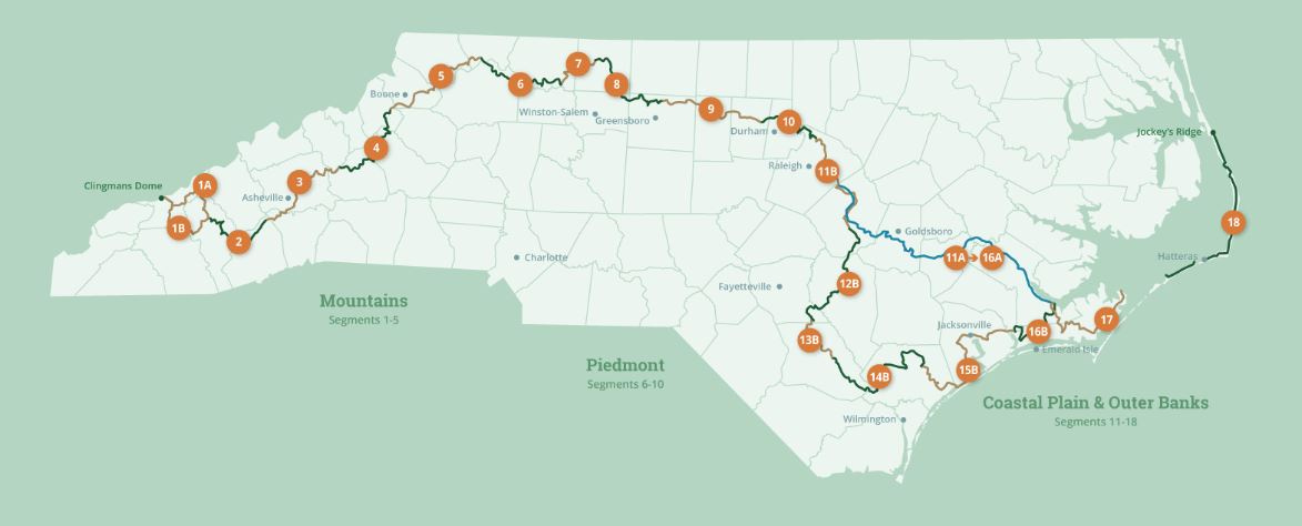
See the Mountains-to-Sea map at the bottom for reference.
Returning to the trail is a strange but wonderful thing. There’s a joy in being, once again, on my own with my backpack and, of course, the challenge of what I am about to do, but, at the same time, I can’t help but feel an “out-of-body” sensation too. Like I am a spectator watching myself as I begin my hike once again. Like it takes a day or two of actually walking to become “one” with the endeavor. I suspect thru-hikers, who stay on a particular trail until it reaches its endpoint, do not understand this feeling, but, for me, coming on-and-off the Mountains-to-Sea Trail throughout the year, as I attempt my goal of walking 1,200 miles across North Carolina, this dual nature of hiking the prescribed eighteen segments has become a strange part of the overall experience, like there are two of us undertaking this ordeal.
I begin each segment at home, it’s like needing to get psyched over and over again — psyched, that is, to gear up each time and not treat my preparation too casually, getting serious a week before, visualizing the walk ahead, and contacting trail angels, if necessary. I must say, I love this crazy adventure that I have come to embrace. I love the people I’ve met, the incredible hikes, the towns, the views—for me, getting psyched is not arduous, but an itch, a tick that I might leave something behind, that I might forget that one critical thing I’ll need.
Rather, for my family, I worry each time that they, too, must get psyched, recognizing they will be at home and not exactly sure of where I’ll be on my journey—if I’ve been hit by a car or truck while walking the brim of a highway or back country road, or even, attacked by a bear or a wild boar in a national forest or state game reserve. Hiking every month for up to a week is a lot tougher on them than it first appears and requires my wife and daughter’s repeated willingness to handle my usual tasks at home while letting whatever happens to me on the trail happen. Their participation, by default, has not come without some angst being expressed, but, I must say, their support has been incredible.
So, here I am about to reenter the world of the Mountains-to-Sea trail, to start up where I left off in Surf City, North Carolina. Surf City being the significant destination back in June where my wife and daughter picked me up near the end of segment 15.
Surf City represents, as well, the last beach town that I’ll encounter hiking the MST. From this point onward the trail turns inland and begins its circuitous route towards the Great Smoky Mountains. Still, even though I’ve walked 300 miles already, before I leave the eastern part of the state, I’ll have 300 more miles to go before I have officially reached the MST’s “piedmont segments.” I’ll cross public game lands, remote towns, battlefields, agricultural fields, and state parks and forests—all with very few campgrounds, motels, and other amenities at my ready.
Relying on trail angels to undertake the Mountains-to-Sea Trail is a must. As on other long distance hikes, trail angels are volunteers who, if called upon, have agreed to help thru-hikers with advice and/or transportation to towns, stores, or select spots where camping is allowed. For those of us not used to asking for such help, trail angels are a feature of the MST that one must learn to utilize to complete the trail.
Today, as I drive to Surf City, the feeling of discombobulation is intense. I have been off the trail for three months now due to July and August being so hot, and in September, due to a wonderful change-up with my wife and daughter when we took a two-week trip to Croatia, Montenegro, Slovenia, and Venice. But, now, here I am in the middle of October driving east to Sneads Ferry where Tim Supple, the MST Trail Coordinator for Section 15, has agreed, once again, to let me spend the night in his RV. First, though, he has asked me to speak to his Rotary Club at noon.
I feel good about myself. I am stronger physically and mentally and have recovered from the aches and foot pains from the spring. I am happy to be starting up again and, in truth, could not have imagined this long of a hiatus from when I stopped back in June. Talking to the Rotary Club is a perfect way to remind myself why I am doing this, why it has been so hard and so much fun.
I arrive at the appointed hour and find the room full of seventy and eighty year-old Rotarians and, as I am of a similar age, I am asked many questions about why am I doing this. Why not, seems to be my answer. It’s here, it runs through Sneads Ferry, like many other small towns in North Carolina that I would never otherwise see, why not go for it before our age catches up with us.
I remind them I have already delayed my walk by three months!
Crazy to think that the most difficult time to hike the MST is in the summer. However, mid-to-high ninety degree temperatures in July and August quickly brought my walk with my thirty-pound pack to a self-imposed, health-alert stand still. Especially, in studying the MST trail guidelines and, later, driving much of the route back in August, I realized that the difficulties ahead would require being somewhat more astute.


One immediate obstacle has been the Holly Shelter Game Lands just north of Surf City. The Holly Shelter is a state-owned, 64,500-acre parcel of natural forest, pocosin, and swampy lowlands set aside primarily for hunters. The MST weaves through the game lands from south to north for twenty miles before reaching a busy secondary road that hikers take to Burgaw, the first town after Surf City, and, to be clear, a life-saving, resupply stop on this stretch.
This trip, my goal is to take on the Holly Shelter Game Lands once and for all.
The hike didn’t look too bad when I first viewed the map back in the spring. I had walked such distances before, but in planning to undertake this part of the trail, I then realized, I would need first to walk nine miles from Surf City to get to the Holly Shelter entrance, and, after I walked out of the game lands twenty miles later, I would have thirteen more miles to get to Burgaw, North Carolina, where the Burgaw Motel stood like a shiny, sleep-inducing oasis. In total, this would be a hike of forty-two miles and a distance I definitely could not manage in one day!
Back then, with my wife and daughter, “my team,” I call them, our discussion centered on two issues: camping, approved by the State only at the Holly Shelter’s northern and southern terminal points, and water. The question of water— where would be my last accessible point and how much would I need to carry to get through this stretch—dominated our conversation. Given the lack of stores after the first five miles and other very limited water locations, we determined, in truth, I would need to set up temporary water stations with hidden bottles of water in the game shelter itself before attempting this section of the hike. Even so, I couldn’t imagine hiding enough water bottles at the Shelter’s terminal points for two days of hiking in the open game lands under 90 degree temperatures.
Back in June I discussed all of this with Tim Supple, the Trail Coordinator. This was when I stayed in the RV next to his house. Tim agreed with my assessment, saying he had, on occasion, arranged water pickups for other hikers. He agreed, I would need his help when I returned in July. Less than two weeks later, however, my team and I decided to wait out the hot temperatures now baking the state.
All that is to say, in early October when I texted Tim my plans to start up, once again, I couldn’t have been more ecstatic when he agreed to help. My idea, though, had changed in the three months off the route. Instead of taking on one long thru-hike and all the water and camping issues therein, I now proposed to do it through a series out-and-back day hikes, using my car as the starting point to walk to a midway point in the Shelter, coming up from the south, and then the next day hiking down to the mid-point from the north—my car loaded with a case of water for both directions!
Tim listened and invited me to overnight in his RV, which I gladly accepted. He said he would see what he could do about my proposed series of hikes from my car.
Tim is such a big, open, kind-hearted guy. To hike segment 15 of the MST without interacting with Tim, I’ve more than once concluded, would be a huge mistake. His advice, assistance, and, for that matter, willingness to let me to sleep in his RV, has proven to be invaluable on more than one occasion.
After lunch with the Sneads Ferry Rotary I decide to drive to Surf City and begin the MST, picking up where I stopped three months earlier. I park my car in the public beach parking lot and check out the Atlantic Ocean from the pier, taking pictures of the ocean as well as the iconic Shaka Taco takeout where Karen, Helen and I ate the last time I was here. I proceed across the long bridge separating Surf City and the island of Topsail from the mainland and walk the first five miles towards the Holly Shelter Game Lands. Reaching a Lowe’s shopping center where I could leave my car the next morning, I hike back to Surf City and drive to Tim’s RV in Sneads Ferry.
At Tim’s suggestion, I join his family that night for a pizza party. He and his wife, Cathy, (whom he always calls his bride) are celebrating their eleventh wedding anniversary, and, along with their young children, family, and friends, he introduces me to Cath and Nancy, two retirees who have joined them for dinner and are members of the local Sneads Ferry hiking club.
Funny how the MST makes for such moments. Who would have thought a day ago I would be eating pizza near the coast with such a nice group of people. Nancy and Cath are also supporters of the MST and want to walk it one day. Most importantly, they have agreed to help me tomorrow. Surprised, I am truly relieved when they offer to unlock the puzzle of how I can navigate the Holly Shelter Game Lands.
The next morning a mouse joins me in the RV — much to Tim’s consternation! The mouse doesn’t want to hike, however, and runs behind the stove when I depart.


I drive to the Lowe’s parking lot and load up with extra bottles of water from my case in the back. For this hike I carry my day pack instead of my larger backpack and love being free of the extra weight. Hiking four miles to the game land entrance along the side of Route 17 proves to be no picnic, though, as cars and trucks wiz by me on the four-lane highway. Still, I meet some great people at a garden center I pass along the way who invite me inside for coffee and a bathroom break. I can’t stay long, unfortunately, as Cath has agreed to meet me at the southern entrance.
Cath arrives as I arrive and tells me to get into her Subaru Outback. Slowly we drive the entire length of the game shelter. I didn’t realize the state allows cars in the reserve, but hunting season has begun and the gates are open. Twenty miles of bouncing along and an hour later, she drops me off at the northern terminus. From here I will walk all the way back through the game lands and down Route 17 to get to my car in the Lowe’s parking lot. As crazy as it seems, this gives me a preview of my hike for the day for which I am most grateful.


With a late start to hike the twenty-four miles to my car, I don’t delay and determine that I will eat lunch (and change my socks) after completing the first ten miles in the game lands. The walk proves to be a series of extremely long straight-aways with deep stretches of black bogs from the recent rains. I do my best to remain in good spirits, but, I must say, the distances are unnerving.
Along the way I meet Larry Warren who has spent the morning hunting with his hounds. Larry has a few dogs in cages in the back of his truck who continue to bark their greetings as we talk. He has been whistling and honking his truck horn for his other dogs to return and guesses they have caught the scent of a fox. He lives twenty miles away and loves being here with his hounds where they can run free. I wish him the best of luck retrieving his dogs and, though I can hear them off in the distance, I can only imagine how long it will take for them to return to Larry’s truck.
I am glad to have had a chance to drive these roads. Otherwise, I might have freaked out with all the visually unappealing straight-aways. In the mid-afternoon, a drizzling rain arrives and changing socks proves to be an art in balancing and keeping dry. Near the end of the reserve it’s nice seeing stands of Longleaf Pine once again.


Late in the afternoon I come out of the game lands and stop at the garden center for a second respite before walking the final miles back to my car. The brim of a rush-hour Route 17 is unnerving, especially after twenty miles of solitude. With a total hike for the day of twenty-eight miles, I am absolutely delighted to reach my car.
Even though I walked south through the Holly Shelter from its northern terminus, rather than westward from south to north, I have now completed segment 15 of the MST. To celebrate, I look forward to lying down and sleeping in the RV.
Tim, though, contacts me and within an hour of arriving back, and we are off in his truck to dinner at a local, busy restaurant. Again, Tim seems to know everyone. Standing in line for 45 minutes waiting for a table while he “works” the room nearly kills me, but I enjoy a veggie burger and fries even though I am sure on my own I would have skipped eating all together and hung out in the RV with Mr. Mouse.
The next day, my last on the trail, I am up early and drive to Burgaw. I meet Tim’s hiking friend Nancy at the local MacDonald’s and she drives me to the Holly Shelter’s northern terminus. From here, I turn away from the game lands and walk back the thirteen miles to Burgaw where I retrieve my car. I can only imagine how this must look as I change out of my socks and shoes sitting in the back of my SUV.
A customer walks past and notices that I have been hiking. “Where can you hike around here?” he asks.
I point to the Holly Shelter Game Lands thirteen miles away and say, “There’s 65,000 acres of public lands just over there.” —Game lands, I don’t mention, that I have been dwelling on for three months. Game lands, I want to say, that are now forever behind me. My path is westward and, walking to Burgaw, the start of segment 14 has begun. But it, too, will require logistical help, as it’s thirty-eight miles to the next town.
That afternoon I leave my “hiking persona” behind and drive home on I-40. With a hot cup of coffee from the Brown Dog Cafe in downtown Burgaw, I determine not to worry about the next segment of the MST and focus instead on how amazing Tim has been and how helpful his friends Cath and Nancy were to shuttle me through the Holly Shelter. I realize that hiking on my own out-and-back from my car through the game lands would have been horrible, given the daunting straight-aways. Like incredible angels, which I realize, once again, is the soul of the MST, Tim, Cath, and Nancy have made all the difference in my completing this segment.
This reminds me of what I said to the Sneads Ferry Rotarians two days earlier.
“To get serious,” I tell them, “the people I’ve met on the Mountains-to-Sea Trail have been incredible.” I look at the Rotarians in the room. “When I think this hike is too hard or too long, each time I find good people, nice people, people like Tim, like you all, like my family back home, all of you have been so willing to help me. As Rotarians, you understand the nature of service. I am blessed to be on the MST to experience this. With such support, I am learning that the distances ahead, though far, aren’t nearly as far as they, otherwise, would be, and for this, I am most grateful.”
Click here to read the previous chapter.
Click here to read the next chapter.
Map of the Mountains-to-Sea Trail. This post focuses Segments 15b and 14b.
It's great to hear more about this journey! I thought of you last October when I backpacked a stretch of the Mountains to Sea trail in the Shining Rock Wilderness!
Congratulations on navigating this section of the MST. The logistics proved to be extraordinary. In addition to your Camino word of serenity I am sensing a new word of gratitude. Your trail angels are amazing and so are you. Keep charging! ❤️ Marlene