


Bulldozers and Golf Carts
MST. Chapter 14. Segment 16 (Part 5) & Segment 15

This is my serialized story of hiking the Mountains-to-Sea Trail (MST), a 1,175-mile route that crosses the state of North Carolina. I’m hiking west from Jockey’s Ridge near Nags Head on the Outer Banks of the Atlantic Ocean to Kuwohi (formerly Clingmans Dome) near the Tennessee border in the Great Smoky Mountains. If you’d like to start at the beginning of my story, click here.
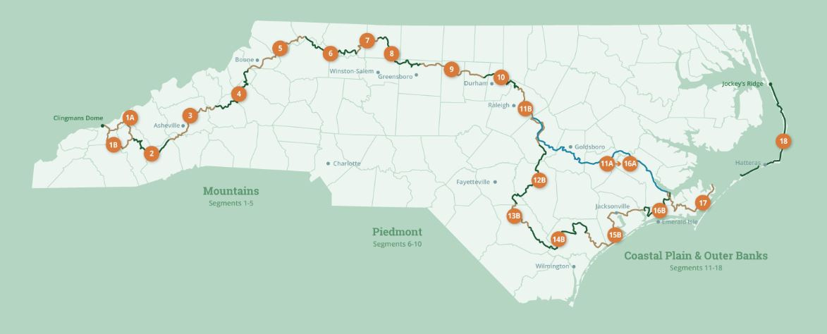
See the Mountains-to-Sea map at the bottom for reference.
I am getting psyched - taking time for pictures at home before I head back out to the Mountains-to-Sea Trail. Though my toes are still black from my previous hikes and the chigger bites have yet to heal, I do love my new gators one of my sisters-in-law sent me from Pennsylvania. Woohoo!
My goal this time out is to hike the final thirteen miles of section 16 of the MST (the Croatan and Neusiok Trail - see previous chapters) and, then, continue on my journey to hike sixty miles of section 15 (The Oslow Bight and Jacksonville). My plan is to end this scheduled time on the trail by lying on the beach at Surf City, NC with my wife and daughter who will drive down the three hours to meet me. Afterward, after tacos we’ve been told we must buy, ice cream, and coffee, I’ll sleep in the back of the car while Karen and Helen endeavor to drive me home.
First, though, to get to where I left off the trail my last time out, Helen drives me to Cape Carteret, NC, where, due to pouring rain two weeks ago, my wife Karen picked me up at the Days Inn motel. As Helen and I, once more, drive back to the Days Inn, I am reminded of how long North Carolina is from east to west. It’s hard to believe I am attempting to hike the whole thing.
Today, with this final thirteen mile stretch in the Croatan National Forest, I will have completed my first two hundred miles of the 1,200-mile trek across the state. Most significantly, in the two hundred miles I walked, I have met great people who I would now call friends, and I have seen amazing sights that I never expected to see, which I hope I will remember for a long, long time.
Clearly, I have a lot of reasons to get started today, but I should have learned by now, nothing comes easy, such as getting to Cape Carteret. On a backroad twenty miles away, we encounter a significant brush fire along the two-lane road and are soon passing tiny fires burning roadside vegetation. Billowing gray smoke from a field to the right of us crosses both lanes of the road and is blinding. For a moment we can’t see anything, including the painted white markers defining our lane. An on-coming car barely sees us, as we, in turn, only catch a glimpse of it in passing.
This must be what fires are like out West or even in the Croatan National Forest back in April when everything was closed down. With the underbrush on fire, along with the trees, how could anyone see what they were doing, let alone, control such blazes.


We make it to the Days Inn, I say goodbye to Helen, and my hike begins. But first, I make a quick stop at a convenience store within a mile of the motel and stock up on Gatorade that I put in the beverage holders on either side of my backpack and a Snickers bar that doesn’t make it out of the parking lot. Shortly thereafter, the trail leaves the left side of Cape Carteret’s busy highway and goes to the right into the national forest.
My thirteen miles hiking the Croatan National Forest is my last in this protected Longleaf Pine habitat. Today’s walk, I discover, features a spectacular juxtaposition between mature Longleaf Pine spread out in a savannah on one side of the logging road and old growth, hardwood forest with its ultra-thick underbrush on the other.
The logging road has been bulldozed into a wide break between the two forest stands, I assume, to keep potential fires from crossing over. With the thick vegetation on the one side, such a leap of wild fire from the pine savannahs would be a disaster, as once it’s over the road, it would be impossible for firefighters to stop. Maybe something like this is what happened earlier in the season. The Forest Service seems to be taking it all seriously, even having teams out on this Sunday as I hike through.


The bulldozed, sandy, logging road is difficult to navigate, and I can tell after ten miles my feet are not happy campers. I will pay for this in the days ahead when I begin walking on hard surfaces. Tomorrow, though, I am excited to walk into Jacksonville and hike near the Marine Corps base of Camp Lejune.


Tonight I reserve a site in a private campground outside the small town of Stella. Though I am not surprised, I discover it is more like a city of RVs. I soon realize I am the only tent among hundreds of RVs and large camper/vehicles. A local resident named Jeff stops me as I wander around searching for street signs and offers me a lift on his golf cart to my site.
He says, “One can easily get lost here if you don’t know where you are going.” He gives me the scenic tour around the city before delivering me to my small patch of grass between two huge RVs.
“Home is where your tent is,” I say to Jeff, as I get out of his golf cart. The neighbors on either side of my rectangular piece of earth, both sets of whom look like they are permanent RV-retiree couples, might beg to differ. They stare in horror as I pull my tent out of my backpack. Clearly, the value of their sites and their glorious vehicles have just taken a nose dive.
That night I think about bulldozers and dream of golf carts on the Mountains to Sea Trail. One has carved out a break through a national forest to stop fires in its path, the other could be quite useful for the days ahead, given most of the next few sections will be spent walking on blacktop - that is, except for the ten miles of beautiful beach between Topsail and Surf City. I swear I can hear the ocean waves calling me from miles away, even over the grind of the bulldozers I’ve passed and the whirr of magical golf carts carrying me above the hum of RV generators throughout the night.
Click here to read the previous chapter.
Click here to read the next chapter.
Map of the Mountains-to-Sea Trail. This post focuses on Segment 16b and 15b.
Kick butt Jonathan. Don't feed the bears...