


Hiking into the Highlands
MST. Chapter 34, Segment 6 (Part 5) & Segment 5

This is my serialized story of hiking the Mountains-to-Sea Trail (MST), a 1,175-mile route that crosses the state of North Carolina. I’m hiking west from Jockey’s Ridge near Nags Head on the Outer Banks of the Atlantic Ocean to Clingmans Dome near the Tennessee border in the Great Smoky Mountains. If you’d like to start at the beginning of my story, click here.
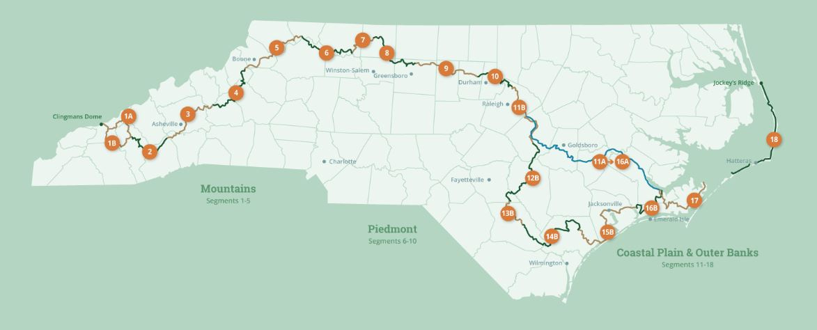
See the Mountains-to-Sea map below for reference.
______________________________________________________________________
It’s hard to comprehend what “straight up” means until you come up against it. Two signs give me warning of the distance ahead: one said I had seven miles to hike to reach the Devil’s Garden Overlook, which is an overlook on the Blue Ridge Parkway high in the Blue Ridge Mountains. I was climbing down from Stone Mountain and could only imagine the next seven miles as a roller coaster—all the way down, then right back up. The other sign, the one more critical—the one I am staring at right now in front of me, the one pointing to a muddy, eroded track that goes straight up an extremely steep mountainside—this one says, in so many words, my life is about to become hell.
Of the two thousand feet I need to climb to reach the Devil’s Garden Overlook, I can see I will immediately address the most horrific aspect of that elevational gain. The next mile or so will be “my epic capstone experience” of climbing into the Blue Ridge Mountains.
The thing is, I can’t go back—not back over Stone Mountain. Going forward is my only option. Besides, reaching the Devil’s Garden Overlook begins my third and final part of the Mountains-to-Sea Trail. With this hike in front of me, I will leave the Piedmont behind and undertake my final three hundred-and-fifty-mile journey through the Blue Ridge and Great Smokey Mountains to reach the trail’s terminus at Clingman’s Dome, one of the highest peaks in the Appalachians.
Such a thought is worthy of a long pause while standing here at the sign that indicates I still have five miles to go to reach the Devil’s Garden Overlook. A gulp of water and a close inspection of the trail ahead, I can see there’s no alternative other than simply to begin. It’s already an hour into the afternoon and I can’t delay any longer—not if I want to camp on top of the mountain tonight. With hiking poles digging into the wet mud, my legs climbing up onto the initial slate of tilted rocks, my push into the Blue Ridge Mountains begins.
I find I must stop about twenty steps into the climb, rest—breathe, breathe, breathe— then start again. Ten steps. Rest. Calm my breathing. Calm down. Start again. This continues over and over as I slowly inch upward—each achievement highlighting another climb up the rugged backbone of the mountainside. No switchbacks, no wooden steps, just a deeply-rutted, narrow trail that appears to be more of a gutted runoff for heavy summer downpours than a key section of the MST. Twenty more steps. Stop. Rest. Catch my breath. Do it again.
The rain picks up and seems to come off me like steam. I think the trees must be deflecting most of the water, though, at this point with so much rain from last night and this morning, who can tell if it’s rain or water dropping from the canopy. Still, I am relieved that I’m not climbing this vertical, slippery slope in temperatures in the mid-nineties—the temperatures I hiked most of the summer. Today with the rain and its socked-in cooler weather, hiking up this mountainside will not involve me potentially having a heat stroke and/or succumbing to my death—now that’s a positive thought.


I am reminded of hiking the Camino de Santiago in Spain nearly two years earlier. I hiked from St. Jean-Pied-de-Port in France to Santiago de Compostela near the Atlantic coast with my sister-in-law, Marlene. So much of today’s hike is like hiking the mountains Marlene and I encountered on the Camino, either when we were reaching up into the Pyrenees Mountains, or crossing the Oca Mountains before encountering the Meseta, or working our way through the Cantabrian Mountains near the end of our journey. I discovered back then, climbing up similar rough trails take time, a willingness to rest, and a steadfast resolve to persevere.
Two-and-a-half hours later I reach the Devil’s Garden Overlook on the Blue Ridge Drive and am now officially in the mountains—as well as finished with Segment Six of the Mountains-to-Sea Trail. The rain has stopped and as part of a long rest on the stone wall to stop cars from driving over the edge, I put on a fresh pair of socks and call home. Celebrating this achievement with my wife Karen and daughter, Helen, is great! I am happy to be here—to be alive—and ready for what lies ahead.


The Segment Five directions indicate I will reach a campground in the Doughton Recreational Area in four miles. At the far end of the Overlook, I spot the MST white circular blaze on a tree. This, then, is where the eighty-five miles of Segment Five begins. I am ready to complete my hike for today, but I know that the blazes and markers will continue for days and days ahead.
Within two miles I pass the Brinegar homestead, now restored and protected by the U.S. National Park Service. Living in the mountains in the late 1890s must have been a tough life. The Brinegars eked out a living doing many jobs for which they were paid and yet volunteered as needed as part the community. Their farm is eye-opening.
Shortly thereafter, I reach a bear sanctuary and am mindful of my presence and my bear spray. I don’t delay in hiking through this area. I pass several open fields along the parkway, and by late afternoon, I am in the campground searching for my site.


I want to enjoy my accomplishment of climbing over Stone Mountain and up into the Blue Ridge Mountains, but I’m too tired to even make dinner and fall asleep in my tent.


In the morning I pack up and am on my way with a goal of hiking ten miles through the Doughton Recreational Area. I am heading to a small crossroads on Route 18 where several motels and a road stop restaurant awaits.
Doughton, though, is far more spectacular than I realized back when I was planning my hike through this segment. The fields of wild flowers are lovely and I enjoy being outside of the woods in the fresh morning air. The views of the mountains to the South, mountains that I will have to surmount are daunting but spectacular.
Within two miles I reach the Bluffs Restaurant on the Blue Ridge Parkway and decide to stop for coffee and breakfast. The part-time waitress, Denyse, is a hiker and full of local information. I love talking with her and order toast with apple butter and a side dish of spiced apple slices. Between the coffee and the apples, as well as Denyse’s insights, I am totally wired by the time I am back on the trail.


Hiking through the open fields on the mountaintop in Doughton Recreational Area is a nice change of pace. I can’t help but think of think of Julie Andrews and The Sound of Music—the surrounding landscape feels full of music.


Soon I reach the end of the mountaintop plateau I have been hiking across and, before following the trail down a hitch, I take a moment on the rocky bluff to enjoy the view. This is everything I could ask for and more. Doughton—who knew?


Early that afternoon, I arrive at the crossroads with NC Route 18 and decide to book a room at the Freeborne’s Motel rather than camp out for the night. It’s the possibility of a shower that clinches it—I want the shower before continuing on tomorrow. I enjoy a nice lunch in the Freeborne restaurant and take a hot shower back in my room. After washing some clothes and falling asleep on the double bed for a long nap, I return to the restaurant for dinner. With nothing on the dinner menu for vegetarians or vegans, I decide to order a hamburger with a fried egg on top along with a side of fries. I eat at the bar surrounded by men with long shaggy beards. One man, who tells me his name is Shake and Bake, whispers over that he is a Democrat and can’t stand Trump. I think I am meant to keep this to myself. Clearly, I am an outsider, like Rip Van Winkle, and beginning to experience the dichotomy of this remote backcountry.
Click here to read the next post.
Click here to read the previous post.
Map of the Mountains-to-Sea Trail. This post focuses on Segments 6 & 5
Doughton Recreation Area looks incredible!
These overlooks are certainly worth the hike of admission! A perfect time of year to experience this spectacular segment of your amazing journey. Continue to recall your Camino mantra, "One stick, one step, one stone" and experience the serenity of these beautiful mountains. ❤️ Marlene