


Camping Behind the Shed
MST. Chapter 8. Segment 17

This is my serialized story of hiking the Mountains-to-Sea Trail (MST), a 1,175-mile route that crosses the state of North Carolina. I’m hiking west from Jockey’s Ridge near Nags Head on the Outer Banks of the Atlantic Ocean to Kuwohi (formerly Clingmans Dome) near the Tennessee border in the Great Smoky Mountains. If you’d like to start at the beginning of my story, click here.
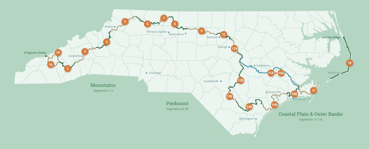
See the Mountains-to-Sea map at the bottom for reference.
Day 6. Once off the ferry from Ocracoke to Cedar Island, it’s onward to my destination at Davis, NC, twenty miles up Rt 12 where I am planning to spend the night. I am chilly when I get off the ferry and for the first time the effort to tackle this next hike leaves me a little depressed - this is the flip side, I guess, of spending a day with my family. Twenty miles constitutes as much as seven hours of walking and, with the ferry not docking at Cedar Island until 10 AM, I won’t get to my destination until around 5 PM. I call the place where I hope to stay in Davis but no one answers.


Soon, however, my natural enthusiasm takes over and I am on my way not realizing how beautiful of a day I will be in for. The Cedar Island Wildlife Refuge turns out to be 14,500 acres of brackish marsh, pocosin, and woodlands. Walking on the highway across it is both daunting and spell-binding. This is only the beginning of a day of incredible vistas that are well beyond the capability of my cellphone or narrative voice.


As crazy as it seems, I am blessed to be able to walk by myself through this habitat, and thank, once more, the gods that be that I have been given the opportunity to see this while walking with my backpack, rather than at the blink of an eye in a car driving 70 to 80 miles an hour.


Such sights continue all day, crossing over bridge after bridge until I reach Davis, where at the last bridge I meet Mike who is fishing just off the embankment. He is from Holly Springs just south of Raleigh and is enjoying his day near the coast fishing for seatrout. As I am talking to him, he suddenly feels a tug on his line, so I take his picture as a fitting conclusion to my walk for the day.


In Davis, things turn sour as I discover the B&B I hoped to stay in is closed. A woman at a local convenience store suggests a yellow house down the street, where, she has heard, the owner takes in boarders from time to time, and, as a second option, she mentions the Baptist church up the way, she says will allow backpackers to camp in the backyard. As I sit outside the convenience store, legs sore from walking 20 miles, I have my work cut out for me. It is already 5 PM and I can’t possibly walk 27 miles more to the next campground.
I always knew this day would come sooner or later, but I didn’t expect it to come this soon.
I go to the yellow house I was directed to approach, but no one answers the door. The house looks like it has been separated into a number of apartments, but no one responds to my knocking on the various doors. I decide to walk on to the Baptist church but I am not sure which church the clerk was referring. The two I check out do not seem to have backyards meant for tents.
A man pulls into his driveway near the second church and when I approach him, he says he never heard of either Baptist church accommodating backpackers. He isn’t sure about the yellow house as it is owned by a hunting club and sits empty on the weeknights, at least until the heights of the summer season.
I go back to the yellow house and knock again but no one answers. With a large yard and a shed near the rear of the property, I decide to put up my tent behind the shed and spend the night- no questions asked - as a clandestine operation that fits perfectly with the shed and my state-of-mind. I jump into my tent and l lie silent, waiting for the tent removal police, but no one sends in the hounds.
No pictures of my tent, nor of the camouflage of hubcaps and rusted bumpers spread around my tent cover - along with fish bones and possum hides - and I don’t emerge from my sanctum until the dead of night to pee, nor until the darkness of early dawn to pack up. With a quick thank you to the Universe, which seems to still have my back, I am on my way to begin the next day’s 27 mile hike.
Click here to read the next chapter.
Click here to read the previous chapter.
Map of the Mountains-to-Sea Trail. This post focuses on Segment 17.
You're hiking big miles. My legs ache for you. You deserve your zero days.